1947 Cartomap Bemidji Minnesota Pictorial Cartoon Map by Harold Hagg Vintage
Regular price $95.00
1918 Battle For Liberty WWI Front Map Fairbault Minnesota Seed Co. Advertising
c.1948 Historical and Illustrated Pictorial Map of Watertown Wisconsin Gruner
c.1945 Pictorial Map of the United States Office War Information WWII Era
Regular price $150.00
1944 Dated Events War Map Stanley Turner C.C. Peterson Pictorial 20th Ed WWII
Regular price $125.00
1941 Greyhound Map of This Amazing America Pictorial Cartoon Map
Regular price $175.00
1935 West Virginia Pictorial Cartoon Map Ruth Taylor Our USA A Gay Geography
Regular price $45.00
1935 Nevada Pictorial Cartoon Map Ruth Taylor Our USA A Gay Geography
1935 South Carolina Pictorial Cartoon Map by Ruth Taylor
c.1970 Mason City and Clear Lake Iowa Pictorial Cartoon Map
Regular price $50.00
c.1950s Grand Rapids Itasca County Minnesota Pictorial Cartoon Map
Regular price $75.00
1959 Little Crow Lake Region of Minnesota Pictorial Cartoon Map
c.1950s Little Crow Lake Region of Minnesota Pictorial Cartoon Map
1982 Welcome To Miller Time In Chicago Pictorial Map Beer Vintage
Regular price $89.00
c.1950 Baltimore Steam Packet Co. Chesapeake Bay Pictorial Map
Regular price SOLD
1983 Waikiki Honolulu Hawaii Pictorial Cartoon Map by Chuck Davis
1926 Map of America's Making
1926 Booklovers Map of America | A Chart of Certain Landmarks of Literary Geography
c.1954 Eating The Italian Way Italy Cuisine Pictorial Map Brochure
c.1970s The Islands of Aloha Airlines Hawaii Pictorial Cartoon Map
1974 New York City Subway Guide Folding Map Massimo Vignelli
c.1950s Long Pine Playground Minnesota Pictorial Cartoon Map Vintage
c.1950s Emily and Outing Vacationaland Minnesota Pictorial Cartoon Map Witkus
1975 Le Vieux Quebec Old Quebec Pictorial Map Poster Mariette Boivin Canada
1960 Navajoland U.S.A. Pictorial Map Navajo Tribal Council Arizona Don Bloodgood
1947 Berks County An Historical Map Pictorial Pennsylvania Dunkleberger
1941 Wisconsin The Badger State Pictorial Map Mentholatum Co. Aitchison
1947 Valley of the Sun Pictorial Cartoon Map Phoenix Central Arizona George M. Avey
1945 Dated Events War Map Stanley Turner C.C. Peterson Pictorial Victory Edition
c.1980 Aerospatiale Helicopter Corp North America Pictorial Cartoon Map Airbus
1958 Park Rapids Minnesota Mississippi Headwaters Region Pictorial Cartoon Map
1978 Dine On The West Side New York City Restaurant Guide Map Poster
1971 Le Belle France Pictorial Map Poster Geisler Publishing Co.
1966 Island of Gaum Pictorial Map Poster South Seas Trading Co Victor A Olsen
c. 1942 Pictoral/Illustrated Map - ADSEC In Action From Thames to Rhine Feed the Flame
1942 Pictoral Map of South America
1947 Map of United States as Californians See It
1934 Figural Map of The Greyhound Lines - A Good Natured Map of the United States
1964 Figural Map of Canada
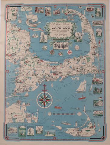
1955 Atlantic Card Company - A Picture Chart of Cape Cod, Martha's Vinyard, & Nanatucket